Fishing GearGarminSold by Fin Feather Fur Outfitters

Garmin

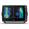
Garmin ECHOMAP Ultra 2 10" Chartplotters 106sv Transducer Navionics

Our editorial team reviews specifications, product data, and field-use information to keep pages accurate.

10-inch Sunlight-readable

WXGA IPS panel and 1280

Available Built-in

Built-in Garmin Navionics+ mapping

Transducer Bundle

Adds Ultra High-Definition scanning sonar

Includes Chirp

Traditional sonar support

Accepts Two

MicroSD cards for added data

$2499.99
View on Fin Feather Fur Outfitters

You'll be taken to Fin Feather Fur Outfitters to complete your purchase.

Hunter's Outpost earns a commission from affiliate links at no extra cost to you.

SKU: 010-02880-01-753759325527

Overview

Built for anglers who want a larger touchscreen helm display, this chartplotter combines navigation and fishfinding functions in one unit. The 10-inch sunlight-readable WXGA IPS screen is suited to boat setups where quick viewing and easy touch control matter, and the built-in Garmin Navionics+ mapping option adds another layer of route and chart detail. In the transducer bundle, Ultra High-Definition scanning sonars and CHIRP traditional sonar expand the unit’s on-water utility for locating structure and interpreting what’s below. With IPX7 waterproofing, bail or flush mounting options, and support for two microSD cards, it fits well in serious fishing rigs that need a capable, centralized display.

Why Hunters Choose the Garmin

10-inch Sunlight-readable

Touchscreen provides a large, crisp

Built-in Garmin

Navionics+ mapping adds integrated charting

Transducer Bundle

Includes Ultra High-Definition scanning sonar

Supports Two

MicroSD cards for expanded data

Stores Up

To 5,000 waypoints for organizing

Key Features

  • 10-inch sunlight-readable touchscreen display with WXGA IPS panel and 1280 x 800 resolution
  • Available with built-in Garmin Navionics+ mapping
  • Transducer bundle adds Ultra High-Definition scanning sonar
  • Includes CHIRP traditional sonar support
  • Accepts two microSD cards for added data storage
  • Supports up to 5,000 waypoints
  • Bail or flush mounting options available

Best Used For

  • Boaters wanting a large touchscreen chartplotter with built-in Garmin Navionics+ mapping
  • Anglers who want Ultra High-Definition scanning sonar and CHIRP traditional sonar in one unit
  • Users needing a waterproof, sunlight-readable display for day-long time on the water
  • Serious fishermen managing many waypoints and multiple microSD cards for trip planning

Specifications

Accepts Data Cards2 microSD cards
Display Resolution1280 x 800 pixels
Display Size8.5" x 5.4"; 10" diagonal (21.7 x 13.6 cm; 25.4 cm diagonal)
Mounting OptionsBail or flush
Product CategoryChartplotters
Product Subcategory10" Chartplotters
Touchscreen Display TypeWXGA, IPS
WaterproofIPX7
Waypoints5000
Weight4.0 lbs (1.8 kg)

Pros

  • 10-inch sunlight-readable touchscreen provides a large, crisp display for navigation and sonar viewing.
  • Built-in Garmin Navionics+ mapping adds integrated charting capability.
  • Transducer bundle includes Ultra High-Definition scanning sonar and CHIRP traditional sonar.
  • Supports two microSD cards for expanded data and map storage.
  • Stores up to 5,000 waypoints for organizing fishing locations and routes.
  • IPX7 waterproof rating adds protection for wet marine conditions.

Considerations & Trade-offs

  • The 10" touchscreen and chartplotter format add capability, but also mean a larger unit to plan for on the console or dash.
  • The transducer bundle includes Ultra High-Definition scanning sonar and CHIRP traditional sonar, which adds functionality but also increases setup complexity compared with a display-only unit.
  • Built-in Garmin Navionics+ mapping is available, but map coverage and detail depend on the specific version and area used.
  • With support for 2 microSD cards and 5,000 waypoints, it offers strong storage and route capacity, though users with extensive data needs may still want to manage card space carefully.

Suggested Comparisons

  • Fishfinder chartplotters
  • Marine GPS navigation systems
  • Sonar transducer bundles
  • Boat electronics displays

Suggested Accessories

  • Marine mounting bracket
  • MicroSD memory card
  • Sonar transducer accessory
  • Protective screen cover

Frequently Asked Questions

Does this ECHOMAP Ultra 2 come with mapping built in?

The product is available with built-in Garmin Navionics+ mapping. The source does not specify whether that mapping is included in every package variation.

What sonar features are included with the transducer bundle?

The transducer bundle adds Ultra High-Definition scanning sonars and CHIRP traditional sonar.

Is the display readable in bright daylight?

The product description says it has a big, crisp, sunlight-readable touchscreen display.

What are the display and screen specifications?

The unit has a 10" diagonal WXGA, IPS touchscreen display with a resolution of 1280 x 800 pixels.

How is this chartplotter mounted and what storage does it accept?

It supports bail or flush mounting and accepts 2 microSD cards.